A border is a line on the map, but on the ground it is a region - a strip of country where the line decides what gets built, who passes through and how people earn a living. Along the EU's eastern frontier that strip runs from Lapland to the Aegean, and it contains some of Europe's strangest twin towns, biggest rail yards and oldest forests. This page is about the lands beside the line.
Twin towns: one river, two worlds
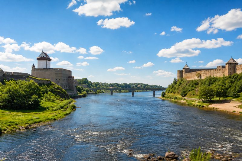
The most concentrated border experience on the whole frontier is at Narva. Estonia's third city stands on one bank of the Narva river; the Russian town of Ivangorod stands on the other. Hermann Castle and Ivangorod Fortress - one built by the Livonian knights, the other by Muscovy - face each other across a few hundred metres of water, and the international bridge runs directly between them. People on both banks live within sight of a boundary that is also the edge of the single market and of two different worlds of paperwork.
The pattern repeats down the line in softer forms. Przemysl in Poland, a Habsburg garrison town with one of Europe's great fortress rings, owes its modern bustle to the Medyka crossing next door and the Kyiv-bound railway through its station. Svilengrad in Bulgaria grew around the road to Istanbul and lives with the traffic of Kapitan Andreevo. On the Tisza, Zahony is less a twin town than a town twinned with its own freight yard.
The break-of-gauge economy
Zahony deserves its own chapter. When the railways of Europe and the Russian empire grew toward each other in the nineteenth century, they used different track gauges - and the seam between the two systems still runs along this border. At Zahony and its Ukrainian counterpart across the river, freight wagons are lifted, unloaded or re-bogied so cargo can continue on the other network. The result is one of the largest rail transshipment complexes in Europe, an entire local economy built on the fact that two sets of rails do not quite fit.
Border economies are option economies: a crossing town earns from what must stop there. Change the rules, the gauge or the route, and the town's income moves with the traffic.
The wild line: forests, marshes, deltas
Because the green border keeps people out, parts of the frontier have become accidental nature reserves. The most famous is Bialowieza, the primeval forest straddling the Polish-Belarusian border - the largest surviving fragment of the lowland forest that once covered Europe, and home of the continent's biggest land animal, the European bison. At the other end of the line, the Danube delta spreads across the Romanian-Ukrainian boundary in a maze of reedbeds and channels, one of Europe's great wetlands. Even the Evros valley, for all its checkpoints, shelters a delta full of birdlife where the river finally reaches the Aegean.
Living with the line
For the people of the borderlands, the frontier is infrastructure, employer and weather all at once. Logistics parks, freight forwarders, fuel stations and markets cluster at the approaches to every major crossing. Bus lines run from border towns deep into the neighbouring countries. When a crossing closes - for politics, pandemics or reconstruction - traffic reroutes by hundreds of kilometres and the towns along the old route feel it immediately, the way a port town feels a lost shipping line.
The line also decides quieter things: where a farmer's field ends, which villages lost their hinterland when the boundary was drawn, why one bank of a river prospers and the other waits. The crossing points are where all of this concentrates; the field notes on visiting the frontier tell you where to see it best - and the customs article explains the machinery that decides how fast the trucks move.